


Tarn, Jonte et Causse Méjean global

Mariolebeno
User
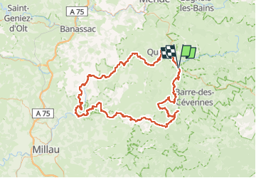

Length
178 km

Max alt
1252 m

Uphill gradient
6427 m
Km-Effort
264 km

Min alt
389 m

Downhill gradient
6429 m
Boucle
Yes
Creation date :
2025-06-02 15:23:31.883
Updated on :
2025-06-02 16:07:37.994
51h30
Difficulty : Difficult

FREE GPS app for hiking
 SityTrail
IGN / Geographical institutes
SityTrail Plus
The world is yours!
About
Trail Walking of 178 km to be discovered at Occitania, Lozère, Florac Trois Rivières. This trail is proposed by Mariolebeno.
Positioning
Country:
France
Region :
Occitania
Department/Province :
Lozère
Municipality :
Florac Trois Rivières
Location:
Florac
Start:(Dec)
Start:(UTM)
547287 ; 4908187 (31T) N.
Comments